TerraGo's Trailblazing GIS Document Integration Technology Helps Louisiana Agencies with Disaster and Recovery Response

Smart means integrated. TerraGo doesn’t just develop integration software, but provides a comprehensive Integration-as-a-Service (IaaS) solution with reliable, worry-free, hands-off operations.
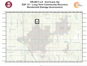
TerraGo's GeoPDF technology provides the ability to create data-driven pages for search and rescue grids that help ease the job of first responders.
BATON ROUGE , LA, UNITED STATES, August 23, 2022 /EINPresswire.com/ -- Although the Internet and mobile technology have significantly enhanced emergency communications, the network can be unreliable during catastrophic disasters. Using the technology available during Hurricane Katrina, the Louisiana Department of Wildlife and Fisheries (LDWF) worked to find survivors using only an intercom and flashlights to communicate and a zip code page from a phone book to determine locations. Seeking to improve communication and rescue efforts in the future, the Federal Emergency Management Agency (FEMA) asked Fran Harvey, a GIS Professional (GISP) and Director of Global Geospatial Solutions (GGS), to create a search and rescue grid that would be scalable from the Louisiana state level to the ground level. GGS specializes in GIS technology that is capable of building digital surveys and/or field mapping applications on mobile devices to accumulate valuable data and
incorporate the capability to visualize data.
Whether it’s used on the front lines or utility lines, TerraGo's GeoPDF software puts the power in the hands of personnel in the field and on the move. Now the industry's most widely adopted geospatial collaboration technology, GeoPDF, utilizes an Adobe Acrobat extension that allows for documents to share information about Geographic Information Systems (GIS). The field-proven, industry-standard GeoPDF technology provides the ability to create data-driven pages for the search and rescue grids that coordinate with the index so a user could know all of the grid cells in the state, which grid cell they were in, and their exact location at any given moment through the index of the PDFs.
Tested in low-tech environments with amazing results, TerraGo's GeoPDF is utilized to deliver imagery to and from U.S. government agencies. In Hammond, LA, several city administrators downloaded TerraGo's free GeoPDF Toolbar plug-in and successfully operated it in a low-technology scenario. They found that GeoPDF did not require a lot of training, was easy to use, and allowed GIS analysts to input a large quantity of valuable GIS information into PDFs. Most importantly, the application could be used by non-GIS users or anyone without access to GIS software and/or a network connection in situations where the Internet or electricity was down. TerraGo products greatly impacted the City of Hammond’s community and provided internal and external users (city employees and citizens) with a lot of useful data and information. "The introduction of our technology into this small town has been the turning point in bringing them into the 21st century, transforming their planning, maintenance, and operations procedures," Harvey said.
The introduction of TerraGo’s technology into this small town has been the turning point in bringing them into the 21st century, transforming their planning, maintenance, and operations procedures tremendously. The user-friendly ability of the GeoPDF technology has led to its wide use in the community, allowing even non-GIS individuals to easily use and apply the tool.
Founded in 2005, TerraGo continues to revolutionize customizable mobile field application software for smart cities and utilities, especially for those in emergency situations who need to walk the streets or travel by boat into flooded areas and manage the area when networks are down. TerraGo now delivers software solutions relied on every day by leading smart cities, utilities, defense, and intelligence organizations in all 50 U.S. states and over 70 countries around the world.
In 2020, TerraGo Technologies announced the availability of TerraGo IoTOps, the newest generation of their zero-code IoT software platform for smart cities and utilities. The launch includes the latest release of TerraGo StreetlightOps, a cloud-based field application tailored to smart lighting operations and their maintenance requirements. The Gen 5 version of TerraGo StreetlightOps was deployed to support the Chicago Smart Street Lighting Program, which recently won a Smart 50 Award for its integrated systems and operational capabilities.
TerraGo recently wrapped up their 15th Geospatial PDF Working Group Meeting webinar in August. The U.S. Government Geospatial PDF Working Group Meeting 2022 included industry sessions detailing the use and creation of GeoPDF applications and geospatial PDF. The group agreed to plan future sessions to discuss how their organizations use technology to enhance their businesses. "With TerraGo Edge, we get GPS-tagged forms that make our entire operations run more smoothly on the devices we all carry anyway," James Henderson, President of Henderson Logistics, said. Lance Fugate, a program manager at Enmapp, also praised TerraGo's services and technology: "The hardware savings are enormous with the new GPS kit at less than $10,000 compared to the old kit which was over $70,000. But the ongoing reduction of project labor costs is even more valuable over time."
Fran Harvey is also the founder and Director of Global Geospatial Institute (GGI), a non-profit dedicated to bringing GIS into the education sector, K-12. In conjunction with GGS's private sector application, TerraGo, GGI works to introduce GIS courses into schools, which has had an enormous impact on young lives, giving them training and work-ready skills for when they graduate from high school. Participating students who have earned a GIS Industry Based Certification (IBC), learn about job opportunities and future prospects that they wouldn't otherwise. GGI's current goal for students is to introduce them to the GeoPDF technology during GGI's course offering, "Remote Sensing Imagery to Smart Maps."
TerraGo's Mission Statement
TerraGo develops software applications and mobile apps that make it easy for our customers to manage assets, collect data, manage IoT devices, connect platforms and work together anywhere, any time. From sharing interactive maps to deploying customized field applications for a mobile workforce, TerraGo builds intuitive products that enable collaboration from any place on the planet. To learn more about TerraGo and its products, visit their website, www.terrago.com
Fran Harvey
Global Geospatial Institute
6783919700 ext.
fharvey@gginstitute.org
Visit us on social media:
Facebook
LinkedIn
Distribution channels: Education, Environment, Natural Disasters, Science, Technology
Legal Disclaimer:
EIN Presswire provides this news content "as is" without warranty of any kind. We do not accept any responsibility or liability for the accuracy, content, images, videos, licenses, completeness, legality, or reliability of the information contained in this article. If you have any complaints or copyright issues related to this article, kindly contact the author above.
Submit your press release

