
Editor’s Note: This story was updated at 8:30 a.m. Tuesday.
CARLISLE JNO BAPTISTE and DANICA COTO
Associated Press

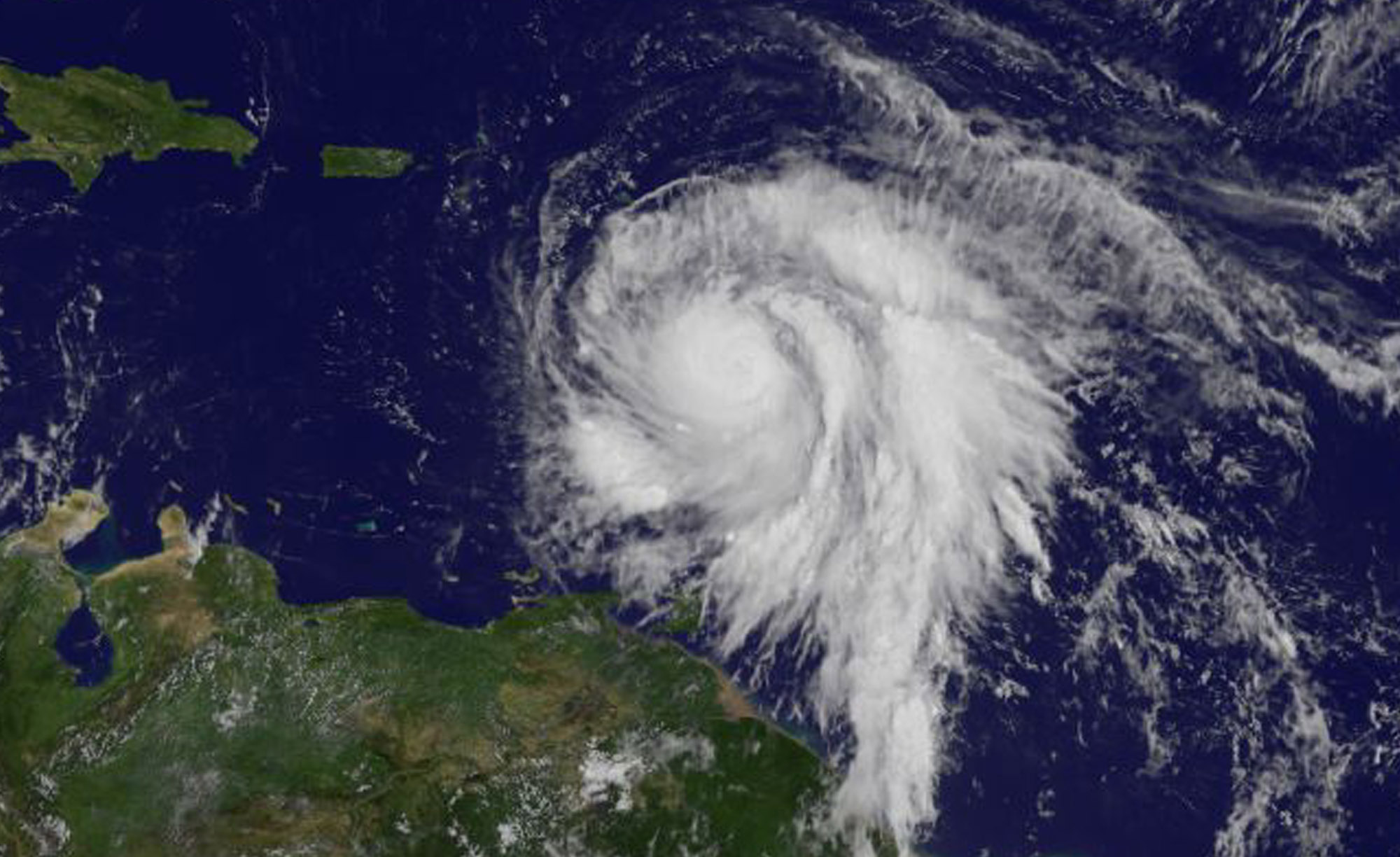
ROSEAU, Dominica (AP) — Hurricane Maria smashed into Dominica with 160 mph winds, ripping the roof off even the prime minister’s residence and causing what he called “mind-boggling” devastation Tuesday as it plunged into a Caribbean region already ravaged by Hurricane Irma.
The storm was on a track to wallop Puerto Rico on Wednesday “with a force and violence that we haven’t seen for several generations,” the territory’s governor said.
Dominica Prime Minister Roosevelt Skerrit said on his Facebook page that “initial reports are of widespread devastation” and said he feared there would be deaths due to rain-fed landslides.
“So far the winds have swept away the roofs of almost every person I have spoken to or otherwise made contact with,” Skerrit wrote. “The roof to my own official residence was among the first to go.”
And he appealed for international aid:
“We will need help, my friend, we will need help of all kinds.”
Maria’s eye roared over the island late Monday night. The storm briefly dipped to Category 4 strength early Tuesday before regaining Category 5 status.
Fierce winds and rain lashed mountainous Dominica for hours. A police official on the island, Inspector Pellam Jno Baptiste, said late Monday night that there were no immediate reports of casualties but it was too dangerous for officers to check conditions.
“Where we are, we can’t move,” he said in a brief phone interview while hunkered down against the region’s second Category 5 hurricane this month.
“The winds are merciless! We shall survive by the grace of God,” Skerrit wrote at the start of a series of increasingly harrowing posts on Facebook.
A few minutes later, he messaged he could hear the sound of galvanized steel roofs tearing off houses on the small rugged island.
He then wrote that he thought his home had been damaged, and added: “Rough! Rough! Rough!”
On the nearby island of Martinique, officials said about 25,000 households were without electricity and two small towns without water after Maria roared past.
The head of French civil security, Jacques Witkowski, told reporters that it was too soon to say whether the French department of Guadaloupe had fared as well.
Prefect Eric Maire, the highest French official of Guadaloupe, said in a video on Twitter that some roads and homes were flooded and heavy rain expected to continue. He told the population to “remain inside.”
Authorities in the U.S. territory of Puerto Rico, which faced the possibility of a direct hit, warned that people in wooden or flimsy homes should find safe shelter before the storm’s expected arrival there on Wednesday.
“You have to evacuate. Otherwise, you’re going to die,” said Hector Pesquera, the island’s public safety commissioner. “I don’t know how to make this any clearer.”
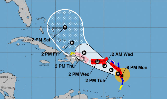
Maria had maximum sustained winds of 160 mph (260 kph) late Monday when it slammed into Dominica.
The U.S. National Hurricane Center said Maria weakened briefly before recovering sustained winds of 160 mph (260 kph) strength shortly before daybreak Tuesday. Its eye was located about 170 miles (275 kilometers) southeast of St. Croix, and the storm was moving west-northwest over the Caribbean at 9 mph (15 kph).
Forecasters warned Maria could even intensify over the next 24 hours or longer, noting its eye had shrunk to a compact 10 miles across and warning: “Maria is developing the dreaded pinhole eye.”
That generally means an extremely strong hurricane will get even mightier, said Brian McNoldy, a hurricane researcher at the University of Miami. He said it just like when a spinning ice skater brings in their arms and rotates faster.
“You just don’t see those in weaker hurricanes,” he said.
The storm’s hurricane-force winds extended out about 35 miles (45 kilometers) and tropical storm-force winds out as far as 125 miles (205 kilometers).
Hurricane warnings were posted for the U.S. and British Virgin Islands, Puerto Rico, Guadeloupe, Dominica, St. Kitts, Nevis and Montserrat. A tropical storm warning was issued for Martinique, Antigua and Barbuda, Saba, St. Eustatius, St. Maarten and Anguilla.
Forecasters said storm surge could raise water levels by 6 to 9 feet (1.8 to 2.7 meters) near the storm’s center. The storm was predicted to bring 10 to 15 inches (25 to 38 centimeters) of rain across the islands, with more in isolated areas.
Close to its path is the island of St. Croix in the U.S. Virgin Islands, where territorial Gov. Kenneth Mapp said Tuesday would be “a very, very long night.”
St. Thomas and St. John are still stunned from a direct hit by Hurricane Irma, which did extensive damage and caused four deaths on the two islands.
Barry University said it chartered a private plane to carry students and staff from its St. Croix facility to Florida in preparation for Maria. It said 72 people connected to the Barry’s Physician Assistant Program and a few pets were on Monday’s evacuation flight.
In neighboring Puerto Rico, nearly 70,000 people were still without power following their earlier brush with Irma and nearly 200 remained in shelters as Maria approached.
Gov. Ricardo Rossello said Puerto Rico had 500 shelters capable of taking in up to 133,000 people in a worst-case scenario. He also said the Federal Emergency Management Agency was ready to bring drinking water and help restore power immediately after the storm, which could hit as a Category 5 hurricane.
“This is going to impact all of Puerto Rico with a force and violence that we haven’t seen for several generations,” he said. “We’re going to lose a lot of infrastructure in Puerto Rico. We’re going to have to rebuild.”
Rossello warned that an island-wide power outage could last a “long time” given the power company’s deteriorated and weak infrastructure.
To the north, Hurricane Jose stirred up dangerous surf and rip currents along the U.S. East Coast, though forecasters said the storm was unlikely to make landfall. Big waves caused by Jose swept five people off a coastal jetty in Rhode Island and they were hospitalized after being rescued.
A tropical storm warning was posted for coastal areas in Rhode Island and Massachusetts, and tropical storm watches were up for parts of New York’s Long Island and Connecticut.
Jose’s center was about 350 miles (560 kilometers) south-southwest of Nantucket, Massachusetts, early Tuesday and moving north at 9 mph (15 kph). The storm had maximum sustained winds of 75 mph (120 kph).
___
Associated Press writers Ben Fox in Miami and Seth Borenstein in Washington contributed to this report. Coto reported from San Juan, Puerto Rico.
*****
This story was updated at 7:30 p.m. Monday —Ed.
Hurricane Maria grew into a Category 5 storm Monday evening as it barreled toward a devastating collision with islands in the eastern Caribbean.
Forecasters warned it was likely to grow even stronger.
The storm was on a path that would take it near many of the islands already wrecked by Hurricane Irma and then on toward a possible direct strike into Puerto Rico on Wednesday.
“This storm promises to be catastrophic for our island,” said Ernesto Morales with the U.S. National Weather Service in San Juan. “All of Puerto Rico will experience hurricane force winds.”
The U.S. territory on Monday imposed rationing of basic supplies including water, milk, baby formula, canned foods, batteries, flashlights and other items.
The U.S. National Hurricane Center said Maria had maximum sustained winds of 160 mph Monday evening.
The hurricane is about 15 miles east-southeast of Dominica and moving west-northwest at 9 mph.
A Hurricane Watch is in effect for:
- Saba and St. Eustatius
- St. Maarten
- St. Martin and St. Barthelemy
- Anguilla
- Isla Saona to Puerto Plata
A Hurricane Warning is in effect for:
- Guadeloupe
- Dominica
- St. Kitts, Nevis, and Montserrat
- U.S. Virgin Islands
- British Virgin Islands
- Puerto Rico, Culebra, and Vieques
A Tropical Storm Warning is in effect for:
- Antigua and Barbuda
- Saba and St. Eustatius
- St. Maarten
- Anguilla
- St. Lucia
- Martinique
ORIGINAL: SAN JUAN, Puerto Rico (AP) – Forecasters said hurricane conditions should begin to affect parts of the Leeward Islands by late Monday, with storm surge raising water levels by 6 to 9 feet near the storm’s center. The storm was predicted to bring 6 to 12 inches of rain across the islands, with more in isolated areas. Officials in Dominica closed schools and government offices on Monday and urged people to evacuate and seek shelters.
“We should not take this storm lightly,” said Prime Minister Roosevelt Skerrit. “Let us continue to pray for our safety.”
Officials in Guadeloupe said the French Caribbean island of would experience extremely heavy flooding starting Monday afternoon, and they warned that many communities would be submerged overnight.
In nearby Martinique, authorities ordered people to remain indoors and said they should be prepared for power cuts and disruption in the water supply. All schools and non-essential public services were closed.
The storm has hurricane-force winds that extend about 15 miles from the eye, and tropical storm force winds out as far as 120 miles. The current forecast track would carry it about 22 miles south of St. Croix in the U.S. Virgin Islands late Tuesday and early Wednesday, according to territorial Gov. Kenneth Mapp.
“We are going to have a very, very long night,” Mapp said as he urged people in the territory to finish any preparations.
St. Thomas and St. John are still recovering from a direct hit by Hurricane Irma, which did extensive damage and caused four deaths on the two islands.
On Wednesday, Maria was expected to be near or over Puerto Rico, which was spared the full brunt of Irma, although much of the island had its power knocked out. Nearly 70,000 people remain without power, and Gov. Ricardo Rossello on Monday warned of another widespread outage.
Forecasters said the storm would dump up to 18 inches of rain across Puerto Rico and whip the U.S. territory with heavy winds for 12 to 24 hours.
Officials said the Federal Emergency Management Agency was ready to bring drinking water and help restore power in Puerto Rico immediately after the storm.
Gov. Ricardo Rossello said officials had prepared about 450 shelters with a capacity for nearly 68,000 people – or even 125,000 in an emergency. There are still nearly 200 people in shelters from Hurricane Irma. Schools were canceled for Monday and government employees would work only a half day.
Farther north, long-lived Hurricane Jose continued to head northward off the U.S. East Coast, causing dangerous surf and rip currents. It was not expected to make landfall but tropical storm watches were posted along the coast from Delaware to Massachusetts’ Cape Cod.
Jose was centered about 265 miles east-southeast of Cape Hatteras, North Carolina, and was moving north at 9 mph. It had maximum sustained winds of 75 mph.
The ocean washed over parts of North Carolina’s Outer Banks as Hurricane Jose passed well to the east, and five people were knocked off a coastal jetty in Rhode Island by high surf caused by the storm. Officials said rescuers had to fight through rough surf to load the injured onto stretchers and get them to shore. All five were taken to a hospital with minor and major injuries.
Pacific threats
In the Pacific, Tropical Storm Norma’s threat to Mexico’s Los Cabos resort area at the southern end of the Baja California Peninsula seemed to ease as forecasters said the storm’s center was likely to remain offshore.
Norma had winds of about 50 mph and it was centered about 175 miles southwest of Cabo San Lucas. The Baja California Sur state government prepared storm shelters and canceled classes for Monday.
Meanwhile, Tropical Storm Lee weakened into a tropical depression far out in the Atlantic while Hurricane Otis weakened far out in the Pacific. Neither threatened land.
Related Videos


